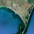
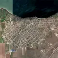
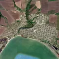
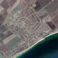
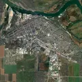
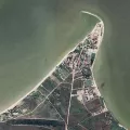
The interactive map of Berdyansk makes it possible to see detailed information about the streets of Berdyansk, buildings and other objects located on the map of Berdyansk.

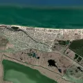
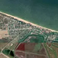
Maps of the Azov Sea provide an opportunity to get acquainted with the cities, resorts and other attractions located on the coast of the Azov Sea. The interactive map of the Azov Sea shows the main cities and towns where you can relax in the summer. To obtain detailed information about the objects on the map of the Azov Sea, you can click on the corresponding designation and go to the full description of the object shown on the interactive map of the Azov Sea. In addition to the general map of the Azov Sea, we have maps of such large cities on its coast as Berdyansk and Kerch, Genichesk, Novoazovsk and Yalta, Taganrog and Yeysk, Mariupol and Azov, as well as smaller settlements on the coast of Azov - Taman and Primorsko-Akhtarsk, Sedovo and Melekino, Shchelkino and Kuchugury, Urzuf and Peresyp, Kirillovka and the village of Golubitskaya, also located on the coast of the Azov Sea.
The interactive map of Berdyansk makes it possible to see detailed information about the streets of Berdyansk, buildings and other objects located on the map of Berdyansk.

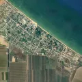
The interactive map of Yeysk shows information obtained from satellite surveys of the area, and also demonstrates an interactive map-scheme of Yeysk.
The interactive map of Kerch makes it possible to see Kerch and its environs on satellite images, a city map and a map of Kerch with objects added by Internet users.
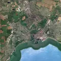
An interactive map of Taganrog makes it possible to explore the territory and surroundings of Taganrog on a map-scheme and on satellite images.
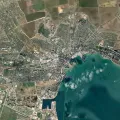
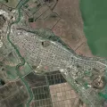
An interactive map of Mariupol allows you to get acquainted with the city and its environs using a schematic map, a satellite map or a map compiled by Internet users.
The interactive map of Taman, presented on our website, allows you to see Taman on satellite images, on a map-scheme of Taman.
An interactive map of the village of Dolzhanskaya will help you understand the features of the territory of the village of Dolzhanskaya, as well as see Dolzhanskaya on a map or satellite images.
Using the interactive map of Temryuk, you can also get acquainted with information about various objects placed on this map, you can view objects and information posted on the map of Temryuk by users.
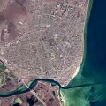
An interactive map of Genichesk shows Genichesk and its surroundings, you can familiarize yourself with the area using a map-scheme, satellite imagery, or explore objects on the map of Genichesk.
The interactive map of Novoazovsk allows you to view satellite images of the territory of Novoazovsk, see the scheme of Novoazovsk, as well as a map of Novoazovsk.
It is possible to view the map of Golubitskaya in satellite imagery mode, a map-scheme or a map of Golubitskaya, on which information is added by residents of the village or vacationers.
The map of Kirillovka has various modes and allows you to view satellite images, a map of Kirillovka or its map, where all the information is posted by ordinary people.
The interactive map of Peresyp allows visitors to our site to view a map-scheme of Peresyp and its environs, satellite images of Peresyp, and also receive various information.

An interactive map of Primorsko-Akhtarsk allows you to get acquainted with the surroundings of Primorsko-Akhtarsk and the territory of the city itself.
The interactive map of Urzuf allows you to view objects on satellite images, Urzuf's scheme and on his people's map, on which everyone can add objects and information.
The interactive map of Kuchugury allows you to explore Kuchugury and its surroundings, having familiarized yourself with satellite imagery of the area and a map-scheme of the village of Kuchugury.
An interactive map of Shchyolkino can be displayed in the satellite imagery, scheme or map mode, on which all objects are plotted by ordinary people familiar with the features of Shchyolkino.
With the help of an interactive map, you can view satellite images of Melekino, a map of the settlement and a map of Melekino, filled in by ordinary users.
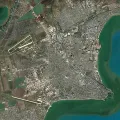
Using the interactive map of Azov, you can see satellite imagery of the area, a map of Azov, as well as a map of Azov, compiled by the efforts of all interested Internet users.
Using the interactive map of Sedovo, you can study its scheme, satellite images and the map of Sedovo, compiled by the efforts of ordinary users.
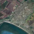
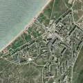
An interactive map of Yalta allows you to get acquainted with the features of Yalta itself and its environs, as well as with various objects located in this region.

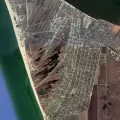
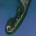
Arabat arrow spit map, interactive map of the Arabat arrow.
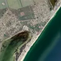
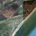
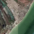
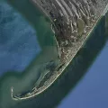
Berdyansk Spit map, interactive map of Berdyansk Spit.
Belosarayskaya spit map, interactive map of Belosarayskaya spit.
Pavlo-Ochakovskaya Spit map, interactive map of Pavlo-Ochakovskaya Spit.